how to georeference and check a property lot plan and a survey
By Engr. Candido R. Talosig, Jr.
Based on an Actual Verification, Relocation and Consolidation/Subdivision Project
Based on an Actual Verification, Relocation and Consolidation/Subdivision Project
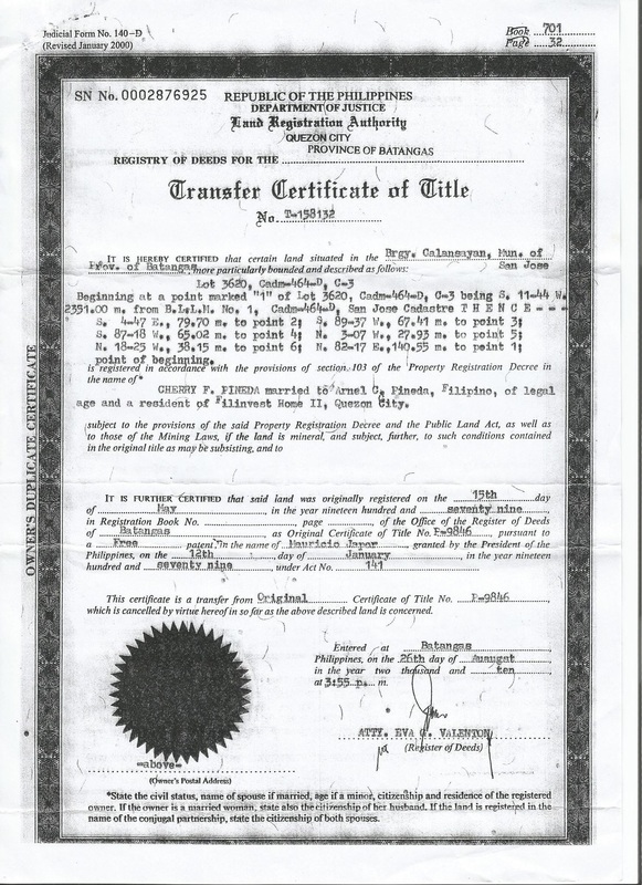
STEP 1. The Client provides a scanned copy of the Property Land Title with the Technical Description printed on it for verification. Take note however that there are Land Titles that has no Technical Description printed on it.
|

STEP 2. Conduct research and investigation at the government agency for Land Management to procure a document for Grid and Geographic Coordinates Certification of the Reference Monument where the property was tied to as well as their Approved Plan and Record of the Technical Description of the Property. Compare the Technical Descriptions and if there is a discrepancy, use the Approved Record of the Technical Description then reconcile and amend thru an Affidavit the Technical Description printed on the Land Title with the proper Government Agency.
|

STEP 3. Plot the Technical Description of the Property using the coordinates of the Reference Monument to Georeference the property in AutoCAD then transform the Grid and Geographic Coordinates to WGS84 Datum Geographic Coordinates for Google Earth. Plot the AutoCAD File to Google Earth using an appropriate software to determine the location of the Reference Monument and the Property Lot Corners.
|

STEP 4. The appropriate software should automatically plot the AutoCAD File to Google Earth and convert the DWG File to Google Earth's KML File. Note the Location of the Reference Monument and verify the boundaries of the property for encroachment and overlap then make a Technical Report.
|

STEP 5. For projects of clients that required planting of Boundary or Lot Monuments, proceed to recover the Reference Monument on the ground based on the location determined from Google Earth.
|

STEP 6. Occupy the Reference Monument using a Survey Grade Dual Frequency GPS to serve as the Reference Point in establishing the Traverse Stations and the location of the Property Lot Corners. Ascertain its Grid and Geographic Coordinates.
|

STEP 7. Use RTK GPS in locating the Traverse Stations and the Property Lot Corners if the area surveyed is an open field. Mark the Traverse Station and plant the Property Monument.
|

STEP 8. For built-up areas or areas covered by trees or nearby Power Lines, use an Electronic Total Station on a Traverse Station with known and established coordinates from the georeferenced Lot Plan and GPS observation in locating the succeeding Traverse Stations and the Property Lot Corners. Mark the Traverse Station and Plant/Mark the Property Monument.
|

The Client's Property Lot Corners Monuments are now located and planted based on a georeferenced Lot Plan and a georeferenced ground survey. All previous surveys conducted were now checked and ascertained. Generate a georeferenced Topographic Map with the appropriate contour interval.
1. Use the georeferenced Property Lot Plan and the georeferenced Topographic Map to prepare a more reliable Master and Site Development Plan of any Land Development Project being conceptualized over the property.
2. Use the georeferenced Traverse Stations, the georeferenced Property Lot Plan, the Georeferenced Topographic Map, the Structural Plan and the Architectural Plan in laying out the landscape, the structures and the utilities to be constructed on the property.
3. Use the georeferenced Property Lot Plan and the georeferenced Topographic Map for accurate Hydrological Studies to design the appropriate Drainage System and the grade of an architectural landscape, a structure or utilities.
4. Use the georeferenced Property Lot Plan and the georeferenced Topographic Map for accurate Soil Profile in Geotechnical Studies.
5. Use the georeferenced Property Lot Plan and Georeferenced Topographic Map to accurately determine the orientation on the Wind Zone of any vertical structure to be designed.
6. Use the georeferenced Property Lot Plan and georeferenced Topographic Map for accurate Geo hazard and Environmental Impact Assessment of a Structural and Land Development Project.
This Web Site was created by Engr. Candido R. Talosig, Jr.
